The spectacular Andes mountain range cuts across Colombia from the green hills of Pasto, through the deserts of Huila, up high towards the giant capital of Bogota, close to the valley of Medellin and down towards the coast in Magdalena.
This chain of mountains helps shape and define South America. It is the home to rich indigenous cultures, extremely rare natural phenomena and many endangered species. The Amazon is the heart of the continent and the Andes is the spine.
In this article, I will discuss treks throughout this varied country that offer a physical challenge as well as a unique experience. These trails take you from ancient civilizations and undiscovered wonders to unique plant life, snowy mountain tops and tropical beaches.
I was born in London but I have lived in Colombia for 15 years and these are some of the best trails in this amazing country, suitable for a range of fitness and experience levels.
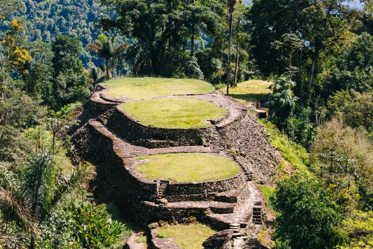
Ciudad Perdida, Magdalena
Distance: 44 km / 27 miles
Total Ascent: 2,200 m / 7,200 feet
Average Hike Duration: 4-5 days
Level: Moderate
Ciudad Perdida (The Lost City) is one of the world’s great ancient wonders with the city believed to be 650 years older than the incredible Machu Picchu in Peru.
The city is believed to have been the political, religious and administrative center of the Tairona people. According to the Kogi, the modern indigenous descendants of this society, the Tairona lived for thousands of years before the Spanish conquistadors arrived in the 16th century.
At the time of European arrival it is believed there were over one million Tairona people with Teyuna, today known as the lost city, the center of this empire of settlements. Initially, the local community traded with the Spanish but over time the European demand for gold resulted in increased violence. Around 60% of Tairona people died defending their land or from the diseases brought by the conquistadors.
With widespread disease decimating the population, the Tairona fled their incredible, sacred capital and their descendants wouldn’t return for centuries. The lost city wasn’t discovered again until 1972 when the Sepúlvedas family were hunting and stumbled across a stone staircase. They followed it up until a remarkable mountain city set within the dense jungle. One of the sons was killed in the squabble for the gold figures and ancient urns. Authorities realized the discovery when remarkable artifacts appeared on sale on the local black market.
Today the area is protected within a national park that covers much of the Sierra Nevada. The Corgi indigenous community continues to live in the region and follow the traditions of their remarkable ancient ancestors who once led one of the biggest civilizations in the Americas.
The trek usually takes 4 to 5 days although some people make their own plans to do it in 3 days. You will need a fairly decent level of fitness but aside from some muddy slopes and a long initial stretch in the sun, most of the route isn’t overly steep or overly hot. You can arrange for an English-speaking guide and along the way you will pass through mountain views, Corgi villages and you can swim in the rivers.
At night you stop in campsites which have either bunk beds or hammocks with food and breakfast provided. The final descent to the Lost City is up 1,200 stone steps before you reach the series of flat grass-covered platforms high above the jungle canopy.
There is a standard official price for the trek which in January 2024 is 2,150,000 COP (US$555) regardless if it is the 4 or 5 day option. Tours leave daily from Santa Marta and as long as you book with a local company you should not have to pay more than this including transfers and a guide.
⏱️ Best Time To Go: Between December and March is when you get the best weather but December into early January is the busiest time to go. May, June, September, October and November is when you get the most rain and the wet mud can make the trek much more difficult.
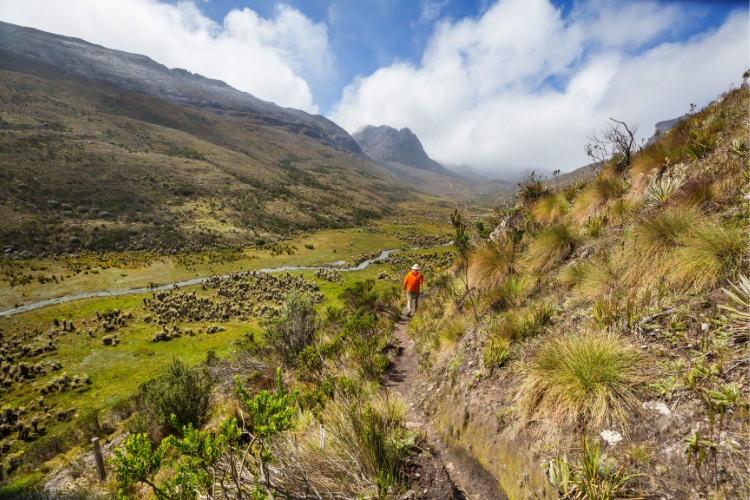
Parque Nacional Natural El Cocuy, Boyacá
Distance: 14 km (8.7 miles), 16 km (10 miles) or 21 km (13 miles)
Highest Altitude: 4,000 m (13,100 ft) above sea level
Average Hike Duration: 1 day
Level: Hard
Parque Nacional Natural El Cocuy (The Cucuy National Natural Park) is a challenging hike to the largest glacial mass in Colombia through high mountains that pass 5,000 meters above sea level. You can expect varied terrain, amazing views and a chance to visit snow-capped mountains.
The park is located across the border of the Boyacá and Arauca departments of Colombia with 3 hiking routes available. Overnight camping routes are no longer permitted in the car.
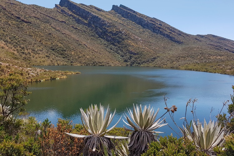
The first heads to the Sierra Nevada de Güicán, El Cocuy and Chita and the Laguna Grande de La Sierra trail which covers 20 km. You will reach the snowy terrain surrounding the Nevado Cóncavo, one of the most beautiful lagoons across the entire Andes mountain range.
The second option is the mountain route that heads to an area called Lagunillas across 21 km finishing the trek at Púlpito del Diablo, “pulpit of the devil” which is a large flat rock above the snow, and Nevado Pan de Azúcar, “snowy sugar loaf” a snow-covered mountain.
The final option is to head along to the snow-covered peak of Ritacuba Blanco, the highest peak in the Eastern Cordillera.
You can get to El Cocuy from the Salitre bus terminal in Bogotá. The journey takes 11 hours and costs around 100,000 COP (US$25). From the small town, you will need to take a 4×4 with a guided tour. There is a maximum capacity for the trails so you should book in advance and go with an approved guide. You can travel independently by bus or pay extra to include private transportation as part of your tour.
Remember to have a warm jacket you can pack away as temperatures range from -2°C up to 20°C.
⏱️ Best Time To Go: The driest months are from December to March and because there are limits on the number of visitors you shouldn’t find the park too busy, even at peak times. The rain can make the cold weather at the peak difficult and you will ideally want a clear day to enjoy the amazing views.
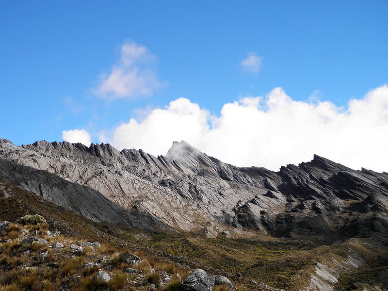
Nevado Santa Isabel, Tolima
Distance: 9 km / 5.6 miles
Highest Altitude: You trek to over 5,000m (16,400 feet) above sea level
Average Hike Duration: 8 hours
Level: Moderate
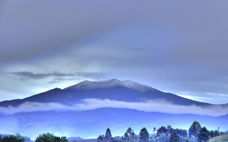
Los Nevados National Natural Park is one of the largest natural reserves in the country, in the heart of the Coffee Region with some of the best trekking routes in Colombia. You can hike up to the top of one of Colombia’s 4 volcanoes and 6 glaciers. Many of the routes are challenging but definitely doable for relative beginners with a decent physical level.
This park is located between the departments of Risaralda, Tolima, Quindío and Caldas with routes heading up the Nevado Santa Isabel, Nevado del Tolima and Paramillo del Quindio.
The easiest route is up Nevado Santa Isabel and can be completed in 2 days but you still get great views and reach the snowy summit. This is a great option if you want a real mountain trek experience but aren’t sure you are ready for a week in a tent and long, steep inclines.
You can book a tour with a guide which leaves from the coffee region cities of Manizales, Pereira, Santa Rosa de Cabal, Salento or Anzoategui. There is less snow at the peak of Nevado Santa Isabel each year and it is predicted that global warming may mean there is none within the next 10 years.
⏱️ Best Time To Go: The weather is driest between December and February and then July to August. There will be the most visitors in mid-December to early January.
Parque Nacional Natural Chingaza, Cundinamarca
Distance: 13 km / 8 miles
Highest Altitude: The trek ranges from 3,400 m (11,150 feet) up to 3,800 (12,367 feet)
Average Hike Duration: 1 or 2 days
Level: Moderate
The Chingaza National Natural Park is located between the Colombian states of Cundinamarca and Meta. The park has a wide range of fauna and flora with a rich culture and history that dates back many centuries.
Indigenous communities of Muisca and Guayupe once dominated this area of the country. The Guayupe numbered an estimated 250,000 when the Spanish arrived in the region while the great Muisca empire is estimated to have had a population of between 500,000 and 3 million. These people developed music, culture, language, food and art which continues to impact on the region up until the present.
Today just under 15,000 identify as Muisca but around 10,000,000 are believed to be descendants.
You can trek various mountain routes with the Chingaza Lagoon and Ramsar popular spots on the way to the beautiful Siecha Lagoons. On the mountains, you may see bears, deer and eagles while in the planes there are pumas and rare birds such as the terlaques toucan.
⏱️ Best Time To Go: December to March is the dry season but you will need warm clothes all year and good boots, particularly if there is a lot of rain.
Caño Cristales, Meta
Distance: Options from 4 km (2.4 miles) if you go direct up to 20 km (12 miles) if you head to Raudal del Guayabero.
Highest Altitude: 470 m / 1,500 feet
Average Hike Duration: Most visitors go direct to Caño Cristales on a boat, road transport and then a 2 km hike. There are full or 2-day options also available to explore different areas of the river and the surrounding countryside.
Level: Easy if direct with more challenging options available
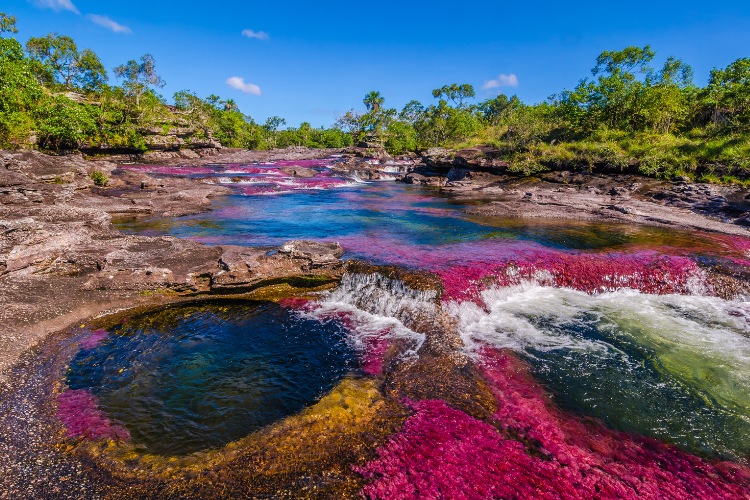
Caño Cristales is one of Colombia’s most unusual, beautiful and celebrated natural phenomena, with “the river of five colors” or the “liquid rainbow” as it is known. The plants along the riverbed leave the water with a red, yellow, green, blue and black color.
The Macarenia Clavigera is responsible for the rich red color and this is the only river in the world where this plant has been found to grow. Formed 1.2 billion years ago, the fast-flowing river has large circular rock pools and waterfalls.
This magical river, known as the most beautiful in the world, is located close to an isolated mountain range in the Sierra de La Macarena National Natural Park in the Department of Meta. It is a very relaxing place to experience nature and there are some great, challenging treks.
To see the full range of colors you need to come between the wet season and dry season so the water isn’t too deep and moving too fast or too shallow. The best time to come is between July and November. You will need to do the trek with a guide as there are limited areas where entering the water is permitted with a maximum of 200 people per day allowed to enter the water, so reserve in advance. You cannot enter with sunscreen or insect repellent to protect the rare, sensitive plants.
The quickest and easiest way to get there is by flying from Bogotá, Medellín or Villavicencio to the municipality of La Macarena. From La Macarena, you can take a boat to the entrance of the park and start of the trails.
⏱️ Best Time To Go: July to November are the busiest periods but also the only months when you are likely to see the colors of the river.
Parque Nacional Natural Puracé, Cauca
Distance: 3 km / 1.9 miles
Highest Altitude: The highest point of the trek is 4,650m (12,256 feet) above sea level
Average Hike Duration: 3 days
Level: Moderate
The Puracé National Natural Park is located in the department of Cauca, 45 kilometers from the city of Popayán. The park has 11 volcanoes with 1 which is constantly active and the key rivers of Magdalena, Cauca, Patía and Caquetáall begin in the park.
Puracé is the only place where you can still see the Andean condor in the wild and it is possible to climb the Puracé volcano. It takes around 5 hours to get to the summit of the volcano and 3 hours to descend along a muddy trail. The climb isn’t particularly difficult but the altitude and slippy conditions add to the challenge.
You can see the craters at the top of the mountains in the park and there are great views.
To climb the volcano you must arrive at 9 am and go with a guide from the park entrance. You can also head to the Piedra del Condor (the rock of the condor) which is around 20 minutes walk from the entrance with a guide who will lay down food so you can see them up close. This guided tour is around 13km which includes a visit to a lagoon, waterfall, the volcanic chain and natural thermal waters.
You can get to the park by bus which takes 2 hours from the Popayán Terminal. There are limited numbers of buses available and the road can be a little rough.
⏱️ Best Time To Go: You can visit all year but the best weather is usually December or January
Parque Tayrona, Magdalena
Distance: 6 km / 3.7 miles
Highest Altitude: 400 meters above sea level
Average Hike Duration: 3 hours
Level: Easy – Moderate
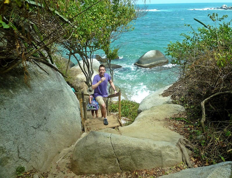
Probably the most popular trek in Colombia is in Tayrona National Natural Park through the forest to the soft sands of La Piscina and Cabo San Juan beaches.
This is an excellent alternative if you want to experience the nature of Magdalena but you don’t have the time or energy to head up into the mountains in search of the lost city. The trek can easily be completed in one day plus if you get to the beach and decide you don’t fancy the walk back to the entrance you can get a speedboat home to Taganga close to Santa Marta.
The trek is straightforward and you follow the path through the forest, over some rocks, across a couple of beaches and then you come out to a nice swimming spot with a restaurant. On the way, you will hear and see monkeys in the trees. It is also possible to spend the night in a tent or a hammock you can reserve.
You can get a bus to the entrance of the park where you have to pay the entry fee and listen to a talk from a park guide. From that point, you can walk or take a quick transfer on a bus to the start of the trek inside the park.
⏱️ Best Time To Go: The park is closed for indigenous religious ceremonies from 1 to 15 February, 1 to 15 June and from 19 October to 2 November. The best weather is at the end and start of the year but late December is very busy. This is the busiest trek on the list.
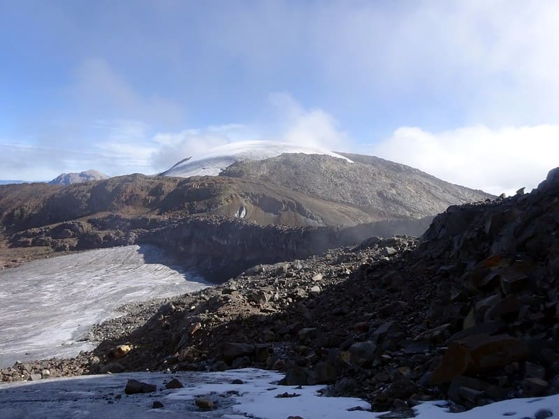
Nevado del Tolima, Tolima
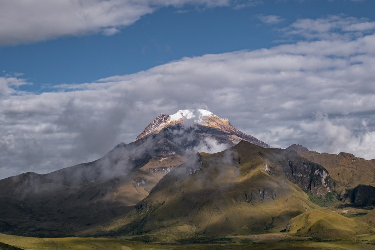
Distance: 52 km / 32 miles
Highest Altitude: 5,280 meters above sea level
Average Hike Duration: Most tours are 4 days but it is possible to do it in 2 days if you move quickly with a strong, experienced guide.
Level: Very Hard
The Nevado del Tolima Volcano is in the Los Nevados National Park with the highest peak reaching 5,280 meters above sea level. The view from the top is spectacular as you look over the Magdalena Valley. The snow-capped peak has some of the best views in the entire country but you definitely have to work for experience.
The 4-day trek is very challenging and you will need to be very strong mentally and physically. Along the way, you will pass hot springs, wide otherworldly valleys and spectacular lagoons with experienced guides.
This trek is not for everyone but those who can make it will be in for a once-in-a-lifetime experience.
You can enter the park at 2 points, the first is close to Salento and the other is nearer the city of Ibague.
⏱️ Best Time To Go: December to March or July to August are the months where you are least likely to get a lot of rain.
Cascada La Chorrera, Cundinamarca
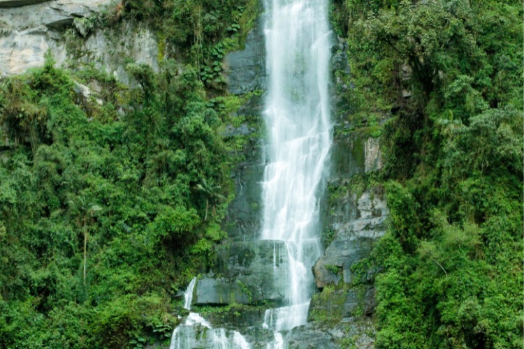
Distance: 5 km / 3 miles
Highest Altitude: 590 meters above sea level
Average Hike Duration: 3 hours
Level: Easy
One of the simplest hikes on this list and one that is very easy to reach from a major city takes you to the highest waterfall in Colombia through fields and a mysterious cloud forest in just a few hours.
It is a fairly straightforward trek but the altitude adds some difficulty and it can get quite boggy if there has been a lot of rain. It is a great way to escape the noise and intensity of the city.
You can camp in the park, go bird spotting plus it is possible to rappel down or climb up the waterfall. They also have an Indiana Jones high-rise ropes course if you are feeling adventurous.
The bus companies Transoriente and Cootransfómeque go direct to the park from the corner of Calle 6 and Avenida Caracas in Bogota. The 90-minute journey costs 10,000 (US$2.50).
⏱️ Best Time To Go: July and August are the months with the best weather but it should be fine all year.